No higher resolution available.
This file and its description are from Wikimedia Commons.
Summary
Licensing
This image was taken from the
Geograph project collection. See
this photograph's page on the Geograph website for the photographer's contact details. The copyright on this image is owned by
Christine Westerback and is licensed for reuse under the
Creative Commons Attribution-ShareAlike 2.0 license.
Attribution: Christine Westerback
You are free:
to share – to copy, distribute and transmit the workto remix – to adapt the work
Under the following conditions:
attribution – You must give appropriate credit, provide a link to the license, and indicate if changes were made. You may do so in any reasonable manner, but not in any way that suggests the licensor endorses you or your use.share alike – If you remix, transform, or build upon the material, you must distribute your contributions under the same or compatible license as the original. https://creativecommons.org/licenses/by-sa/2.0 CC BY-SA 2.0 Creative Commons Attribution-Share Alike 2.0 true true English Add a one-line explanation of what this file represents
creator<\/a>"}},"text\/plain":{"en":{"":"creator"}}},"{\"value\":{\"entity-type\":\"property\",\"numeric-id\":3831,\"id\":\"P3831\"},\"type\":\"wikibase-entityid\"}":{"text\/html":{"en":{"":"
object has role<\/a>"}},"text\/plain":{"en":{"":"object has role"}}},"{\"value\":{\"entity-type\":\"item\",\"numeric-id\":33231,\"id\":\"Q33231\"},\"type\":\"wikibase-entityid\"}":{"text\/html":{"en":{"P3831":" photographer<\/a>"}},"text\/plain":{"en":{"P3831":"photographer"}}},"{\"value\":{\"entity-type\":\"property\",\"numeric-id\":2093,\"id\":\"P2093\"},\"type\":\"wikibase-entityid\"}":{"text\/html":{"en":{"":" author name string<\/a>"}},"text\/plain":{"en":{"":"author name string"}}},"{\"value\":\"Christine Westerback\",\"type\":\"string\"}":{"text\/html":{"en":{"P2093":"Christine Westerback"}},"text\/plain":{"en":{"P2093":"Christine Westerback"}}},"{\"value\":{\"entity-type\":\"property\",\"numeric-id\":2699,\"id\":\"P2699\"},\"type\":\"wikibase-entityid\"}":{"text\/html":{"en":{"":" URL<\/a>"}},"text\/plain":{"en":{"":"URL"}}},"{\"value\":\"https:\\\/\\\/www.geograph.org.uk\\\/profile\\\/753\",\"type\":\"string\"}":{"text\/html":{"en":{"P2699":" https:\/\/www.geograph.org.uk\/profile\/753<\/a>"}},"text\/plain":{"en":{"P2699":"https:\/\/www.geograph.org.uk\/profile\/753"}}}}" class="wbmi-entityview-statementsGroup wbmi-entityview-statementsGroup-P170 oo-ui-layout oo-ui-panelLayout oo-ui-panelLayout-framed"> source of file<\/a>"}},"text\/plain":{"en":{"":"source of file"}}},"{\"value\":{\"entity-type\":\"item\",\"numeric-id\":74228490,\"id\":\"Q74228490\"},\"type\":\"wikibase-entityid\"}":{"text\/html":{"en":{"P7482":"
file available on the internet<\/a>"}},"text\/plain":{"en":{"P7482":"file available on the internet"}}},"{\"value\":{\"entity-type\":\"property\",\"numeric-id\":7384,\"id\":\"P7384\"},\"type\":\"wikibase-entityid\"}":{"text\/html":{"en":{"":" geograph.org.uk image ID<\/a>"}},"text\/plain":{"en":{"":"geograph.org.uk image ID"}}},"{\"value\":\"35551\",\"type\":\"string\"}":{"text\/html":{"en":{"P7384":" 35551<\/a>"}},"text\/plain":{"en":{"P7384":"35551"}}},"{\"value\":{\"entity-type\":\"property\",\"numeric-id\":137,\"id\":\"P137\"},\"type\":\"wikibase-entityid\"}":{"text\/html":{"en":{"":" operator<\/a>"}},"text\/plain":{"en":{"":"operator"}}},"{\"value\":{\"entity-type\":\"item\",\"numeric-id\":1503119,\"id\":\"Q1503119\"},\"type\":\"wikibase-entityid\"}":{"text\/html":{"en":{"P137":" Geograph Britain and Ireland<\/a>"}},"text\/plain":{"en":{"P137":"Geograph Britain and Ireland"}}},"{\"value\":{\"entity-type\":\"property\",\"numeric-id\":973,\"id\":\"P973\"},\"type\":\"wikibase-entityid\"}":{"text\/html":{"en":{"":" described at URL<\/a>"}},"text\/plain":{"en":{"":"described at URL"}}},"{\"value\":\"https:\\\/\\\/www.geograph.org.uk\\\/photo\\\/35551\",\"type\":\"string\"}":{"text\/html":{"en":{"P973":" https:\/\/www.geograph.org.uk\/photo\/35551<\/a>"}},"text\/plain":{"en":{"P973":"https:\/\/www.geograph.org.uk\/photo\/35551"}}}}" class="wbmi-entityview-statementsGroup wbmi-entityview-statementsGroup-P7482 oo-ui-layout oo-ui-panelLayout oo-ui-panelLayout-framed"> inception<\/a>"}},"text\/plain":{"en":{"":"inception"}}},"{\"value\":{\"time\":\"+2002-07-25T00:00:00Z\",\"timezone\":0,\"before\":0,\"after\":0,\"precision\":11,\"calendarmodel\":\"http:\\\/\\\/www.wikidata.org\\\/entity\\\/Q1985727\"},\"type\":\"time\"}":{"text\/html":{"en":{"P571":"25 July 2002"}},"text\/plain":{"en":{"P571":"25 July 2002"}}}}" class="wbmi-entityview-statementsGroup wbmi-entityview-statementsGroup-P571 oo-ui-layout oo-ui-panelLayout oo-ui-panelLayout-framed">
coordinates of the point of view<\/a>"}},"text\/plain":{"en":{"":"coordinates of the point of view"}}},"{\"value\":{\"latitude\":56.57946,\"longitude\":-4.0035,\"altitude\":null,\"precision\":1.0e-5,\"globe\":\"http:\\\/\\\/www.wikidata.org\\\/entity\\\/Q2\"},\"type\":\"globecoordinate\"}":{"text\/html":{"en":{"P1259":"56\u00b034'46.06"N, 4\u00b00'12.60"W"}},"text\/plain":{"en":{"P1259":"56\u00b034'46.06\"N, 4\u00b00'12.60\"W"}}},"{\"value\":{\"entity-type\":\"property\",\"numeric-id\":7787,\"id\":\"P7787\"},\"type\":\"wikibase-entityid\"}":{"text\/html":{"en":{"":"
heading<\/a>"}},"text\/plain":{"en":{"":"heading"}}},"{\"value\":{\"amount\":\"+0\",\"unit\":\"http:\\\/\\\/www.wikidata.org\\\/entity\\\/Q28390\"},\"type\":\"quantity\"}":{"text\/html":{"en":{"P7787":"0 degree<\/span>"}},"text\/plain":{"en":{"P7787":"0 degree"}}}}" class="wbmi-entityview-statementsGroup wbmi-entityview-statementsGroup-P1259 oo-ui-layout oo-ui-panelLayout oo-ui-panelLayout-framed"> coordinates of depicted place<\/a>"}},"text\/plain":{"en":{"":"coordinates of depicted place"}}},"{\"value\":{\"latitude\":56.57982,\"longitude\":-4.0034,\"altitude\":null,\"precision\":1.0e-5,\"globe\":\"http:\\\/\\\/www.wikidata.org\\\/entity\\\/Q2\"},\"type\":\"globecoordinate\"}":{"text\/html":{"en":{"P9149":"56\u00b034'47.35"N, 4\u00b00'12.24"W"}},"text\/plain":{"en":{"P9149":"56\u00b034'47.35\"N, 4\u00b00'12.24\"W"}}},"{\"value\":{\"entity-type\":\"property\",\"numeric-id\":7787,\"id\":\"P7787\"},\"type\":\"wikibase-entityid\"}":{"text\/html":{"en":{"":"
heading<\/a>"}},"text\/plain":{"en":{"":"heading"}}},"{\"value\":{\"amount\":\"+0\",\"unit\":\"http:\\\/\\\/www.wikidata.org\\\/entity\\\/Q28390\"},\"type\":\"quantity\"}":{"text\/html":{"en":{"P7787":"0 degree<\/span>"}},"text\/plain":{"en":{"P7787":"0 degree"}}}}" class="wbmi-entityview-statementsGroup wbmi-entityview-statementsGroup-P9149 oo-ui-layout oo-ui-panelLayout oo-ui-panelLayout-framed"> media type<\/a>"}},"text\/plain":{"en":{"":"media type"}}},"{\"value\":\"image\\\/jpeg\",\"type\":\"string\"}":{"text\/html":{"en":{"P1163":"image\/jpeg"}},"text\/plain":{"en":{"P1163":"image\/jpeg"}}}}" class="wbmi-entityview-statementsGroup wbmi-entityview-statementsGroup-P1163 oo-ui-layout oo-ui-panelLayout oo-ui-panelLayout-framed">
checksum<\/a>"}},"text\/plain":{"en":{"":"checksum"}}},"{\"value\":\"ee65a19bd4e88ca6932ffa0f3bb30d7b16afa6f0\",\"type\":\"string\"}":{"text\/html":{"en":{"P4092":"ee65a19bd4e88ca6932ffa0f3bb30d7b16afa6f0"}},"text\/plain":{"en":{"P4092":"ee65a19bd4e88ca6932ffa0f3bb30d7b16afa6f0"}}},"{\"value\":{\"entity-type\":\"property\",\"numeric-id\":459,\"id\":\"P459\"},\"type\":\"wikibase-entityid\"}":{"text\/html":{"en":{"":"
determination method<\/a>"}},"text\/plain":{"en":{"":"determination method"}}},"{\"value\":{\"entity-type\":\"item\",\"numeric-id\":13414952,\"id\":\"Q13414952\"},\"type\":\"wikibase-entityid\"}":{"text\/html":{"en":{"P459":" SHA-1<\/a>"}},"text\/plain":{"en":{"P459":"SHA-1"}}}}" class="wbmi-entityview-statementsGroup wbmi-entityview-statementsGroup-P4092 oo-ui-layout oo-ui-panelLayout oo-ui-panelLayout-framed"> data size<\/a>"}},"text\/plain":{"en":{"":"data size"}}},"{\"value\":{\"amount\":\"+105045\",\"unit\":\"http:\\\/\\\/www.wikidata.org\\\/entity\\\/Q8799\"},\"type\":\"quantity\"}":{"text\/html":{"en":{"P3575":"105,045
byte<\/span>"}},"text\/plain":{"en":{"P3575":"105,045 byte"}}}}" class="wbmi-entityview-statementsGroup wbmi-entityview-statementsGroup-P3575 oo-ui-layout oo-ui-panelLayout oo-ui-panelLayout-framed"> height<\/a>"}},"text\/plain":{"en":{"":"height"}}},"{\"value\":{\"amount\":\"+480\",\"unit\":\"http:\\\/\\\/www.wikidata.org\\\/entity\\\/Q355198\"},\"type\":\"quantity\"}":{"text\/html":{"en":{"P2048":"480
pixel<\/span>"}},"text\/plain":{"en":{"P2048":"480 pixel"}}}}" class="wbmi-entityview-statementsGroup wbmi-entityview-statementsGroup-P2048 oo-ui-layout oo-ui-panelLayout oo-ui-panelLayout-framed"> width<\/a>"}},"text\/plain":{"en":{"":"width"}}},"{\"value\":{\"amount\":\"+640\",\"unit\":\"http:\\\/\\\/www.wikidata.org\\\/entity\\\/Q355198\"},\"type\":\"quantity\"}":{"text\/html":{"en":{"P2049":"640
pixel<\/span>"}},"text\/plain":{"en":{"P2049":"640 pixel"}}}}" class="wbmi-entityview-statementsGroup wbmi-entityview-statementsGroup-P2049 oo-ui-layout oo-ui-panelLayout oo-ui-panelLayout-framed"> File history
Click on a date/time to view the file as it appeared at that time.
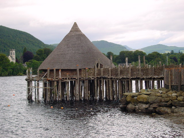
Date/Time Thumbnail Dimensions User Comment current 12:48, 30 January 2010 640 × 480 (103 KB) wikimediacommons>GeographBot == {{int:filedesc}} == {{Information |description={{en|1=Crannog. A defensive home built about 5000 years ago in Loch Tay.}} |date=2002-07-25 |source=From [http://www.geograph.org.uk/photo/35551 geograph.org.uk] |author=[http://www.geograph.org.uk/profile
File usage
The following 3 pages use this file:
This file contains additional information, probably added from the digital camera or scanner used to create or digitize it.
If the file has been modified from its original state, some details may not fully reflect the modified file.


_heading:0.00&language=en)
_heading:0.00&language=en)
